Tangzhou Ancient City Ruins
⭐ 2.00
Tangzhou Ancient City Ruins, Libo County, Qiannan Autonomous Prefecture, Guizhou Province, China
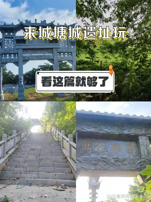 Constructed in the third year of Emperor Qianlong's reign (1738), the Datang fortress arose from one of the most ambitious administrative reforms in Qing imperial history. The "Gaitu Guiliu" policy—roughly analogous to Europe's contemporary Enlightenment-era push to replace feudal lords with crown-appointed officials—aimed to integrate the mountainous Miao and Bouyei territories into the Chinese bureaucratic system. Datang served as a "Limiao" sub-prefecture, literally "Miao-governing," stationed along the vital courier road linking Guizhou's capital Guiyang to the southern coast. The fortress fell during civil conflict in 1868, after which the county seat relocated and the site gradually returned to farmland.
In its prime, the garrison was encircled by marble walls rising roughly five meters high and stretching nearly a kilometer in circumference—dimensions comparable to small bastioned European forts of the same period. Today, that grandeur survives only as broken courses of stone scattered across cultivated plots, where erosion and vegetation have erased the original defensive silhouette. Visitors can still trace the cardinal positions of the east, west, south, and north gates, and detect faint outlines of the grid street pattern beneath their feet. Nothing has been reconstructed or landscaped; the site presents itself honestly, like a forgotten Scottish border peel tower melting back into pasture.
Datang offers scholars a rare, undisturbed stratigraphy of Qing southwestern frontier policy and its human cost. Local oral traditions speak of a "White Bone Tomb" commemorating casualties of late-nineteenth-century unrest, lending the ruins a memorial gravity reminiscent of Civil War battlefield sites in the American South. Surrounding Bouyei and Miao villages, whose traditional stilted houses still dot the nearby ridgelines, illustrate the multi-ethnic contact zone the fortress was built to control—an Asian parallel to Habsburg-era Transylvania, where imperial garrisons oversaw culturally distinct populations along fragile frontiers.
Reaching Datang requires determination. The site lies within Pingtang County's Datang Township but holds no heritage designation above the prefectural level, meaning there are no visitor services whatsoever. Travelers must self-navigate by GPS to the township, then ask locals for directions to the field areas where the foundations lie. Expect muddy, uneven terrain after rain—sturdy hiking boots with good grip are essential. There are no restrooms, signage, parking, or food stalls; bring water, snacks, sun protection, and offline navigation files since mobile signal can be unreliable.
This is emphatically not a destination for casual sightseeing or family outings with young children. Instead, it rewards local historians, ruin photographers, and adventurous travelers who derive satisfaction from piecing together fragmentary evidence on the ground. Those who make the journey often combine it with Pingtang's Yazhou pottery heritage workshops, the Wangchengguan sunset viewpoint, and—further afield—the celebrated karst cascades of Libo's Xiaoqikong Scenic Area, forming a rich multi-day cultural circuit through southern Guizhou's lesser-known interior.
Constructed in the third year of Emperor Qianlong's reign (1738), the Datang fortress arose from one of the most ambitious administrative reforms in Qing imperial history. The "Gaitu Guiliu" policy—roughly analogous to Europe's contemporary Enlightenment-era push to replace feudal lords with crown-appointed officials—aimed to integrate the mountainous Miao and Bouyei territories into the Chinese bureaucratic system. Datang served as a "Limiao" sub-prefecture, literally "Miao-governing," stationed along the vital courier road linking Guizhou's capital Guiyang to the southern coast. The fortress fell during civil conflict in 1868, after which the county seat relocated and the site gradually returned to farmland.
In its prime, the garrison was encircled by marble walls rising roughly five meters high and stretching nearly a kilometer in circumference—dimensions comparable to small bastioned European forts of the same period. Today, that grandeur survives only as broken courses of stone scattered across cultivated plots, where erosion and vegetation have erased the original defensive silhouette. Visitors can still trace the cardinal positions of the east, west, south, and north gates, and detect faint outlines of the grid street pattern beneath their feet. Nothing has been reconstructed or landscaped; the site presents itself honestly, like a forgotten Scottish border peel tower melting back into pasture.
Datang offers scholars a rare, undisturbed stratigraphy of Qing southwestern frontier policy and its human cost. Local oral traditions speak of a "White Bone Tomb" commemorating casualties of late-nineteenth-century unrest, lending the ruins a memorial gravity reminiscent of Civil War battlefield sites in the American South. Surrounding Bouyei and Miao villages, whose traditional stilted houses still dot the nearby ridgelines, illustrate the multi-ethnic contact zone the fortress was built to control—an Asian parallel to Habsburg-era Transylvania, where imperial garrisons oversaw culturally distinct populations along fragile frontiers.
Reaching Datang requires determination. The site lies within Pingtang County's Datang Township but holds no heritage designation above the prefectural level, meaning there are no visitor services whatsoever. Travelers must self-navigate by GPS to the township, then ask locals for directions to the field areas where the foundations lie. Expect muddy, uneven terrain after rain—sturdy hiking boots with good grip are essential. There are no restrooms, signage, parking, or food stalls; bring water, snacks, sun protection, and offline navigation files since mobile signal can be unreliable.
This is emphatically not a destination for casual sightseeing or family outings with young children. Instead, it rewards local historians, ruin photographers, and adventurous travelers who derive satisfaction from piecing together fragmentary evidence on the ground. Those who make the journey often combine it with Pingtang's Yazhou pottery heritage workshops, the Wangchengguan sunset viewpoint, and—further afield—the celebrated karst cascades of Libo's Xiaoqikong Scenic Area, forming a rich multi-day cultural circuit through southern Guizhou's lesser-known interior.