Bayan Har Pass
⭐ 3.50
Bayan Har Pass, Golmud, Qinghai, China
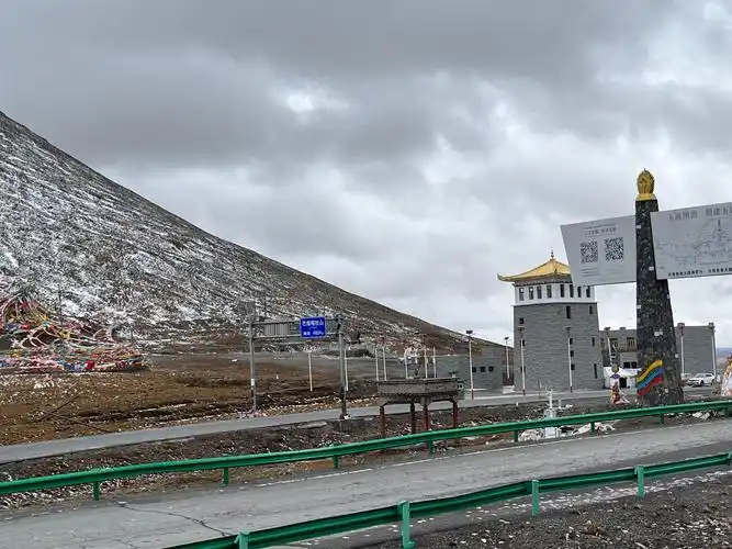 Rising where the roof of the world begins to flatten into rolling steppe, Bayan Har Pass serves as a dramatic hydrographic divider that geography enthusiasts will find hard to beat. To the north flows the Yueguzonglie channel, one of the Yellow River's remotest headwaters, while southward trickles the northern tributary of the Yangtze — two of humanity's most important water arteries parting from a single saddle. Comparable in significance to the Continental Divide of the Americas yet dwarfing it in elevation, this pass lets visitors physically straddle the birthplaces of civilizations that have sustained East Asia for millennia.
Long before highways carved their way across the plateau, Bayan Har marked a critical waypoint on the Tang-Tibet Ancient Road, the ceremonial artery linking imperial Chang'an to Lhasa. In 641 AD, Princess Wencheng's wedding caravan reportedly traversed these very heights on her diplomatic marriage to Songtsen Gampo, an event that shaped centuries of Sino-Tibetan relations much like the legendary Silk Road exchanges forged cultural bonds between Rome and the Han court. A modern stone monument and a string of color-saturated Tibetan prayer flags commemorate this pilgrimage heritage at the summit itself.
The surrounding landscape reads like a masterclass in pure high-altitude ecology, where cobalt skies collide with the snow-dusted Bayan Har range and the endless green-gold grassland stretches unbroken toward every horizon. The pass sits within the heart of the Sanjiangyuan National Nature Reserve, providing some of the best roadside wildlife viewing in Asia — Tibetan antelope, wild yak, and black-necked cranes roam these meadows as freely as bison once roamed the American plains. Photographers will find frame-worthy compositions around nearly every bend of the highway.
Practical visitors should treat the pass seriously despite its free, unmarked access. With oxygen at less than 60 percent of sea-level concentration, lingering beyond 30 minutes risks acute mountain sickness; even a short walk to the prayer flags can leave lungs gasping. July and August bring the mildest temperatures, oscillating between 5 and 20 degrees Celsius, though fierce wind and sudden hail can strike without warning. Travelers must bring insulated jackets, oxygen canisters, glucose supplements, and all drinking water — the pass offers only a basic parking pull-off and absolutely no commercial facilities.
For a richly layered itinerary, anchor a three-day circuit around the pass itself. Begin by acclimatizing in Madoi County to the west, home to the sapphire twin lakes of Zhaling and Eling plus the symbolic Niu Tou Bei monument marking the Yellow River's source. Then push east to Bayan Har before overnighting in the charismatic Tibetan town of Jieguzhen near Yushu, gateway to the Princess Wencheng Temple and the stunning Jana Mani stone scripture wall. Return along the well-maintained G109 and G214 corridors via licensed minivans equipped with supplemental oxygen, the safest way to absorb these vertiginous landscapes without compromise.
Rising where the roof of the world begins to flatten into rolling steppe, Bayan Har Pass serves as a dramatic hydrographic divider that geography enthusiasts will find hard to beat. To the north flows the Yueguzonglie channel, one of the Yellow River's remotest headwaters, while southward trickles the northern tributary of the Yangtze — two of humanity's most important water arteries parting from a single saddle. Comparable in significance to the Continental Divide of the Americas yet dwarfing it in elevation, this pass lets visitors physically straddle the birthplaces of civilizations that have sustained East Asia for millennia.
Long before highways carved their way across the plateau, Bayan Har marked a critical waypoint on the Tang-Tibet Ancient Road, the ceremonial artery linking imperial Chang'an to Lhasa. In 641 AD, Princess Wencheng's wedding caravan reportedly traversed these very heights on her diplomatic marriage to Songtsen Gampo, an event that shaped centuries of Sino-Tibetan relations much like the legendary Silk Road exchanges forged cultural bonds between Rome and the Han court. A modern stone monument and a string of color-saturated Tibetan prayer flags commemorate this pilgrimage heritage at the summit itself.
The surrounding landscape reads like a masterclass in pure high-altitude ecology, where cobalt skies collide with the snow-dusted Bayan Har range and the endless green-gold grassland stretches unbroken toward every horizon. The pass sits within the heart of the Sanjiangyuan National Nature Reserve, providing some of the best roadside wildlife viewing in Asia — Tibetan antelope, wild yak, and black-necked cranes roam these meadows as freely as bison once roamed the American plains. Photographers will find frame-worthy compositions around nearly every bend of the highway.
Practical visitors should treat the pass seriously despite its free, unmarked access. With oxygen at less than 60 percent of sea-level concentration, lingering beyond 30 minutes risks acute mountain sickness; even a short walk to the prayer flags can leave lungs gasping. July and August bring the mildest temperatures, oscillating between 5 and 20 degrees Celsius, though fierce wind and sudden hail can strike without warning. Travelers must bring insulated jackets, oxygen canisters, glucose supplements, and all drinking water — the pass offers only a basic parking pull-off and absolutely no commercial facilities.
For a richly layered itinerary, anchor a three-day circuit around the pass itself. Begin by acclimatizing in Madoi County to the west, home to the sapphire twin lakes of Zhaling and Eling plus the symbolic Niu Tou Bei monument marking the Yellow River's source. Then push east to Bayan Har before overnighting in the charismatic Tibetan town of Jieguzhen near Yushu, gateway to the Princess Wencheng Temple and the stunning Jana Mani stone scripture wall. Return along the well-maintained G109 and G214 corridors via licensed minivans equipped with supplemental oxygen, the safest way to absorb these vertiginous landscapes without compromise.