Khunjerab Pass
⭐ 4.60
Khunjerab Pass, Tashkurgan Tajik Autonomous County, Kashgar Prefecture, Xinjiang, China
 Long before borders hardened into checkpoints, this windswept saddle guided caravans along a southern branch of the ancient Silk Road, linking Kashgar's oasis markets with the royal courts of Gandhara and Mughal Lahore. The Tajik word "Khunjerab," meaning "Blood Valley," recalls the tribes and armies that contested these passes for millennia. The modern crossing opened in 1969 and, until December 2024, operated only seasonally from May to October. Its year-round status, secured when China and Pakistan extended the legendary Karakoram Highway, marks a quiet diplomatic milestone as significant, in its regional way, as the reopening of the Simplon or Brenner Passes in 19th-century Europe.
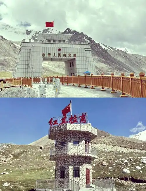
The architecture is deliberately austere. A monumental granite gateway crowned with the national emblem rises from the ridgeline at 5,100 meters—the loftiest border portal anywhere on the planet. In summer, the gate's clean geometry contrasts with the wild Pamirs beyond, where Muztagh Ata (7,546 m) and the endless white of the Karakoram rival anything in the Alps or Himalaya. In winter, the entire tableau vanishes into a blizzard-lit dreamscape. Across the plaza, Boundary Marker No. 7 marks the precise meeting point of the two nations, an unassuming stone that nevertheless carries the weight of more than half a century of Sino-Pakistani friendship.
This is also a place of memory. For Chinese travelers, Khunjerab has acquired the aura of a secular pilgrimage, akin to the way Italians once crossed the Stelvio Pass or Americans paused at Trail Ridge Road—sites where national identity fuses with raw geography. Local soldiers of the People's Liberation Army endure brutal winters here, and the steady presence of the frontier guard lends the site a solemn, almost monastic gravity. Visitors sense it immediately: this is not scenery to be admired from a tour bus, but a threshold to be approached with humility.
Reaching the pass demands preparation. Foreign travelers cannot visit independently; they must join a tour operated by a Xinjiang-licensed agency that pre-registers the itinerary with border police. From Kashgar the round trip is roughly 800 kilometers along the treacherous, switchback-laden G314—best appreciated by comparison to Norway's Trollstigen or Italy's Stelvio in sheer drama. Most itineraries overnight in Tashkurgan (3,100 m) for one or two nights to acclimatize; the air here holds barely half the oxygen of sea level, and altitude sickness is a real danger. Even in July, daytime temperatures hover near freezing and katabatic winds howl at 7–8 on the Beaufort scale.
Pack accordingly: a windproof shell, fleece layers, insulated gloves, UV-blocking sunglasses, and either a rented oxygen canister or glucose supplements. Move slowly—no running, no jumping—stay hydrated, and skip alcohol entirely. The viewing platform and gate plaza are open to visitors, typically between 10:30 and 19:30; the customs and inspection zones beyond are strictly off-limits. Photography rules are firm: drones are forbidden, military personnel and facilities cannot be filmed, and barriers around Boundary Marker No. 7 must not be crossed. Weekend closures are common, so confirm the day's status with your operator before departing Kashgar.
Why make the effort? Because in an age when travel has been thoroughly mapped and Instagrammed, Khunjerab still feels like the edge of the known world. Standing beneath that flag at over 5,000 meters—closer, in atmosphere, to the summit of Mont Blanc than to the valley of the Loire—is to feel the planet's scale reassert itself. Few places on earth allow a foreign visitor to legally set foot in two nations in a single step while gazing upon mountains that dwarf the Andes. It is exhausting, inconvenient, and occasionally uncomfortable, and that is precisely why it remains unforgettable.
Long before borders hardened into checkpoints, this windswept saddle guided caravans along a southern branch of the ancient Silk Road, linking Kashgar's oasis markets with the royal courts of Gandhara and Mughal Lahore. The Tajik word "Khunjerab," meaning "Blood Valley," recalls the tribes and armies that contested these passes for millennia. The modern crossing opened in 1969 and, until December 2024, operated only seasonally from May to October. Its year-round status, secured when China and Pakistan extended the legendary Karakoram Highway, marks a quiet diplomatic milestone as significant, in its regional way, as the reopening of the Simplon or Brenner Passes in 19th-century Europe.
The architecture is deliberately austere. A monumental granite gateway crowned with the national emblem rises from the ridgeline at 5,100 meters—the loftiest border portal anywhere on the planet. In summer, the gate's clean geometry contrasts with the wild Pamirs beyond, where Muztagh Ata (7,546 m) and the endless white of the Karakoram rival anything in the Alps or Himalaya. In winter, the entire tableau vanishes into a blizzard-lit dreamscape. Across the plaza, Boundary Marker No. 7 marks the precise meeting point of the two nations, an unassuming stone that nevertheless carries the weight of more than half a century of Sino-Pakistani friendship.
This is also a place of memory. For Chinese travelers, Khunjerab has acquired the aura of a secular pilgrimage, akin to the way Italians once crossed the Stelvio Pass or Americans paused at Trail Ridge Road—sites where national identity fuses with raw geography. Local soldiers of the People's Liberation Army endure brutal winters here, and the steady presence of the frontier guard lends the site a solemn, almost monastic gravity. Visitors sense it immediately: this is not scenery to be admired from a tour bus, but a threshold to be approached with humility.
Reaching the pass demands preparation. Foreign travelers cannot visit independently; they must join a tour operated by a Xinjiang-licensed agency that pre-registers the itinerary with border police. From Kashgar the round trip is roughly 800 kilometers along the treacherous, switchback-laden G314—best appreciated by comparison to Norway's Trollstigen or Italy's Stelvio in sheer drama. Most itineraries overnight in Tashkurgan (3,100 m) for one or two nights to acclimatize; the air here holds barely half the oxygen of sea level, and altitude sickness is a real danger. Even in July, daytime temperatures hover near freezing and katabatic winds howl at 7–8 on the Beaufort scale.
Pack accordingly: a windproof shell, fleece layers, insulated gloves, UV-blocking sunglasses, and either a rented oxygen canister or glucose supplements. Move slowly—no running, no jumping—stay hydrated, and skip alcohol entirely. The viewing platform and gate plaza are open to visitors, typically between 10:30 and 19:30; the customs and inspection zones beyond are strictly off-limits. Photography rules are firm: drones are forbidden, military personnel and facilities cannot be filmed, and barriers around Boundary Marker No. 7 must not be crossed. Weekend closures are common, so confirm the day's status with your operator before departing Kashgar.
Why make the effort? Because in an age when travel has been thoroughly mapped and Instagrammed, Khunjerab still feels like the edge of the known world. Standing beneath that flag at over 5,000 meters—closer, in atmosphere, to the summit of Mont Blanc than to the valley of the Loire—is to feel the planet's scale reassert itself. Few places on earth allow a foreign visitor to legally set foot in two nations in a single step while gazing upon mountains that dwarf the Andes. It is exhausting, inconvenient, and occasionally uncomfortable, and that is precisely why it remains unforgettable.