Zhu-Mao Shoulder Pole Path
⭐ 2.50
Zhu-Mao Shoulder Pole Path, Ciping Town, Jinggangshan City, Jiangxi Province, China
 In the autumn of 1928, Mao Zedong's fledgling rural soviet on Jinggang Mountain was on the brink of starvation. Nationalist troops sealed every road. Aged 35 and 42 respectively, Mao and his co-commander Zhu De led soldiers on hundred-li round trips, shouldering roughly 150 tonnes of rice up precipitous slopes. The campaign's most famous episode became "Zhu De's Carrying Pole": when staff tried to spare their general, he insisted on carrying his share alongside common fighters. Like WWII's partisan supply chains in the Italian Apennines or the French Maquis, the operation fused survival with ideological solidarity—and helped pioneer Mao's doctrine of "encircling the cities from the countryside."
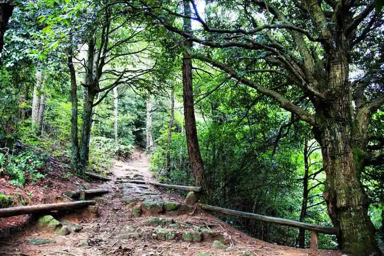
Stretching 3.1 kilometres from the Huangyangjie pass below toward the mountain's interior, the trail alternates between narrow earth tracks and uneven granite steps, with substantial elevation gain. Rain turns the red clay slick; even in dry weather the gradients are punishing. Midway stands the path's emblem—a centuries-old oak tree under whose broad canopy Mao allegedly paused for rest. The tree survives, still leafing each spring, a single living witness to the column of carriers who passed beneath it nearly a century ago. Original terrain has been preserved with minimal paving, retaining the authenticity that gives the experience its bite.
For Chinese visitors, walking this trail is a near-pilgrimage. Jinggangshan is considered the "cradle of the revolution"—the place where Mao first combined armed struggle, land reform, and rural base-building into the strategy that eventually carried his movement to power in 1949. The grain-carrying campaign embodied the principle that leaders and led must share deprivation: an ethic later encapsulated in "serve the people." Party branches, school groups, and corporate teams still come in their thousands to retrace it. For foreign visitors, the trail offers something rarer: a tangible sense of the bodily hardship that shaped twentieth-century China's political DNA.
The trail lies beneath the Huangyangjie scenic area, within Jinggangshan City—a county-level city administered by Ji'an—roughly two hours' drive from Ji'an urban district. No direct public bus exists. Most travellers arrive via Jinggangshan Airport or high-speed rail to Ji'an, then transfer to the mountain's tourist shuttle. From the Huangyangjie parking area, a short walk reaches the trailhead. The core experience covers 2.1–2.5 km one way; allow two to three hours for the round trip, longer if you carry a simulated grain sack. On-site commentary is in Mandarin only, so booking an English-speaking guide in advance is strongly recommended.
This is a place to feel history in your calves and shoulders, not merely read it on a placard. Don a rented Red Army uniform at the trailhead, hoist a 10–20 kg sandbag onto a bamboo pole, and the abstraction of "revolutionary sacrifice" becomes wonderfully, uncomfortably concrete. Combine the trail with neighbouring Huangyangjie—where a few hundred Red Army soldiers repelled a much larger force using rolling logs and a single broken cannon—and the Bajiaolou octagonal study where Mao drafted key texts. Sturdy hiking shoes, water, sun and rain protection, and insect repellent are essential; in summer temperatures exceed 35 °C and mosquitoes are fierce.
In the autumn of 1928, Mao Zedong's fledgling rural soviet on Jinggang Mountain was on the brink of starvation. Nationalist troops sealed every road. Aged 35 and 42 respectively, Mao and his co-commander Zhu De led soldiers on hundred-li round trips, shouldering roughly 150 tonnes of rice up precipitous slopes. The campaign's most famous episode became "Zhu De's Carrying Pole": when staff tried to spare their general, he insisted on carrying his share alongside common fighters. Like WWII's partisan supply chains in the Italian Apennines or the French Maquis, the operation fused survival with ideological solidarity—and helped pioneer Mao's doctrine of "encircling the cities from the countryside."
Stretching 3.1 kilometres from the Huangyangjie pass below toward the mountain's interior, the trail alternates between narrow earth tracks and uneven granite steps, with substantial elevation gain. Rain turns the red clay slick; even in dry weather the gradients are punishing. Midway stands the path's emblem—a centuries-old oak tree under whose broad canopy Mao allegedly paused for rest. The tree survives, still leafing each spring, a single living witness to the column of carriers who passed beneath it nearly a century ago. Original terrain has been preserved with minimal paving, retaining the authenticity that gives the experience its bite.
For Chinese visitors, walking this trail is a near-pilgrimage. Jinggangshan is considered the "cradle of the revolution"—the place where Mao first combined armed struggle, land reform, and rural base-building into the strategy that eventually carried his movement to power in 1949. The grain-carrying campaign embodied the principle that leaders and led must share deprivation: an ethic later encapsulated in "serve the people." Party branches, school groups, and corporate teams still come in their thousands to retrace it. For foreign visitors, the trail offers something rarer: a tangible sense of the bodily hardship that shaped twentieth-century China's political DNA.
The trail lies beneath the Huangyangjie scenic area, within Jinggangshan City—a county-level city administered by Ji'an—roughly two hours' drive from Ji'an urban district. No direct public bus exists. Most travellers arrive via Jinggangshan Airport or high-speed rail to Ji'an, then transfer to the mountain's tourist shuttle. From the Huangyangjie parking area, a short walk reaches the trailhead. The core experience covers 2.1–2.5 km one way; allow two to three hours for the round trip, longer if you carry a simulated grain sack. On-site commentary is in Mandarin only, so booking an English-speaking guide in advance is strongly recommended.
This is a place to feel history in your calves and shoulders, not merely read it on a placard. Don a rented Red Army uniform at the trailhead, hoist a 10–20 kg sandbag onto a bamboo pole, and the abstraction of "revolutionary sacrifice" becomes wonderfully, uncomfortably concrete. Combine the trail with neighbouring Huangyangjie—where a few hundred Red Army soldiers repelled a much larger force using rolling logs and a single broken cannon—and the Bajiaolou octagonal study where Mao drafted key texts. Sturdy hiking shoes, water, sun and rain protection, and insect repellent are essential; in summer temperatures exceed 35 °C and mosquitoes are fierce.